Capturing Pre-Flood Conditions
- Mar 15, 2019
- 1 min read
AeroView's flight crews have been busy capturing pre-flood conditions along the Mississippi River and tributaries. Municipalities and government agencies know the value of proper documentation.
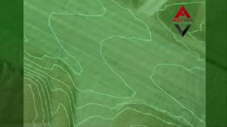
AeroView can quickly fly over an area to capture the data necessary to generate an orthophoto, contour map and even 3D surface model of a property. All of the data AeroView generates is compatible with CAD design software and GIS software commonly used by government agencies. If you only need still photos or video of a tough to access area we can help with that, too.
The ability to compare pre-flood to post flood conditions is invaluable in the planning process for future high water events. Optimized planning keeps flood fight - and flood repair - costs at a minimum. Something all taxpayers can appreciate.
If you would like to discuss how we can help you document your pre-flood conditions, high water levels and determine post-flood damage feel free to call us at 515-505-3510 ex: 702 or email sales@avqld.com.


Comments