"Above the Mud" xyHt Feature Article
The Iowa DNR looks to AeroView when they need quality data. Check out the December 2018 xhHt magazine to learn how we helped the DNR capture topographic data for a time critical environmental remediation project.

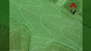
The key takeaway from the article is that drone data can work in conjunction with traditional surveying methods. The drone captured a TON of great data in areas that were not economical or even possible to survey with a GPS, robot or laser scanner. By merging the two data sets the DNR has the best of both worlds.

If you need help taking your drone data to the next level feel free to reach out to to me - zach@avqld.com. Our team can fill any gap in your drone to CAD process.
Below, Jeremiah Allen with the Iowa DNR shares his experience working with AeroView over the past few years. Unfortunately, xyHt did not have enough space to include Jeremiah's thoughts in print but we are happy to share his experience here.
We met Zach in mid November 2015 at a Geospatial Workshop put on by Trimble and our local vendor, Precision Midwest.
From our first interaction, it has been a breeze dealing with AeroView's staff.
Our first project was a 160 acre lake bottom mapping job at Union Grove State Park, in Tama County. We had drained the lake and the day before the planned flight, we had a large rainfall, partly filling the lake. Because of the time of year, late November, we were concerned about the weather impacting the survey. Even when we had unforeseen site conditions that prevented data collection, re-scheduling flight days was a manageable process. In the end, we were successful in collecting the photos and were very happy with the resulting info collected. I still use these photos in presentations where I compare UAS photos to other publicly accessible aerial photos.
Because of our success at Union Grove, we scheduled another flight at Pleasant Creek State Rec Area, north of Cedar Rapids in Linn County. This was a larger scope at 500 acres and was also a drained lake site. Lucky for the us, the weather in late February 2016 was warm enough for the UAS and camera to operate. This job was larger and required the stitching of multiple flight tiles. We also were tasked with larger point clouds of data than we have ever used in the past. With the guidance from AeroView’s team, we were able to work through these issues and process this data easily.
Our third flight was at Geode State Park in Henry County, another drained lake project. It was still a large site at 420 acres and it required 2 landing/takeoff sites. We lucked out again with warm weather in late November 2017 but the strong variable wind was an issue at this location. This was overcome with some hard work from the AeroView staff and we received the data a short time later.
Over the 2 1/2 years of being a AeroView customer, AeroView has consistently improved their level of service and made the process increasingly easier each time we contract with AeroView.
After being on site many times with the AeroView team, I was inspired to become a Remote Pilot Certificate holder. After some guidance from a AeroView team member, I found the test preparation material that fit my needs and became a part 107 Remote Pilot Certificate holder in early February 2018.
I look forward to working with AeroView in the future on large scale flight projects and also smaller projects where AeroView processes photos we provide when we acquire our own UAS. This company definitely has the expertise and experience we need and have come to rely on.
Jeremiah Allen, Construction Surveyor, Iowa Dept of Natural Resources